Vision
Communities caring for, and connecting with healthy forests, alps and waterways
Introduction
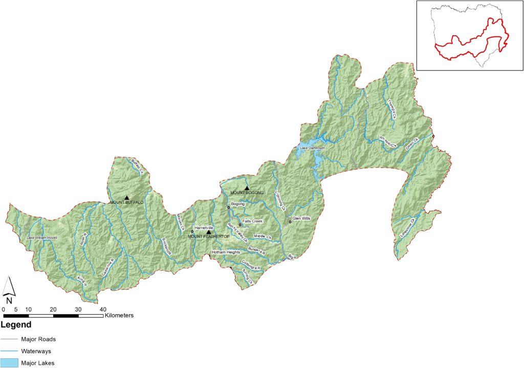
A visually spectacular area containing extensive areas of forest and alpine vegetation. This landscape has the headwaters for many of north east Victoria’s rivers and a range of biodiversity hotspots.
This landscape is significant to a number of Traditional Owners/First Nations Peoples, and to many people for ceremonial and celebration purposes as well as for food and resource collection in certain seasons.
It supports high levels of nature-based tourism and the alpine resorts attract a transient winter population. Most of this landscape is Parks Victoria managed public land in partnership with Traditional Owners/First Nations Peoples where joint management is in place, and by DELWP and Alpine Resort Management Boards.

What is important?
Important attributes
Important attributes of the Alpine and Forested Parks identified by those who live, work, visit or connect with this landscape include:
- A diversity of scenic natural landscapes with extensive forested and alpine vegetation and other unique environments that are protected by large areas of parks and reserves
- Strong industry of nature-based recreation for adventure and relaxation
- Headwaters of several of the region’s waterways providing some of the most reliable and high-quality water to the region and Murray-Darling Basin[40]
- Diversity of native flora, fauna and communities that are dependent on the alpine environment including many ecologically and culturally important and threatened species
- Extensive Traditional Owners/First Nations Peoples and European cultural heritage
- Alpine landscape and climate are unique in the Australian context.
Key features
| Theme | Key features |
|---|---|
| Land | Majority of landscape is Parks Victoria managed public land in partnership with Traditional Owners/First Nations Peoples where joint management is in place, and by DELWP and Alpine Resort Management Boards. Some areas of land are planted with soft wood plantations owned by HVP plantations. There are small pockets of mixed farming and livestock grazing. Includes parts of the Alpine and Mount Buffalo National Parks, which support remarkable geodiversity, landscapes and scenic views. Significant mountain peaks, Mt Bogong (Victoria’s highest peak) and Mt Feathertop (Victoria’s second highest peak) are both in this landscape. Hosts the major Alpine resorts of Falls Creek and Mt Hotham as well as the alpine village of Dinner Plain. Soils vary – they are shallow in the alpine environment and can be deep and waterlogged at the bottom of basins and valleys. |
| Water | Includes the headwaters of many of the north east’s major rivers including King, Buffalo, Ovens and Kiewa. Priority waterways include the Buffalo, Buckland, Kiewa River East & West Branch, Ovens, Big, King, Catherine, Bundara, Dandongadale Rivers and many other significant creeks. Contains priority wetlands including Mount Buffalo and Mount Bogong Peatlands, and Davies Plain. Peatlands are crucial for providing habitat for moderating and filtering water-flows ensuring pristine water quality leaves the alpine areas to benefit users in the Murray-Darling Basin. Contains several water storages including Lake Dartmouth and Lake William Hovell. Smaller remnants of gold mining dredges exist in Harrietville which are mostly used for water recreation. |
| Biodiversity | Supports many flora and fauna species that have limited distribution and very specialised habitat requirements such as the Bogong moth and Mountain Pygmy-possum. Above the treeline the alpine zone is a mosaic of heathlands, grasslands, herbfields and wetlands interspersed by rock and rock pavements. Supports montane forests of peppermint gum, snow gum woodlands and stands of Alpine ash. Some important species and communities that are significant to this landscape include: Flora: Alpine ash (Eucalyptus delegatensis) Snow gum (Eucalyptus pauciflora) Buffalo mint-bush (Prostanthera monticola) Snow-wort (Abrotanella nivigena) Bogong sallee (Eucalyptus pauciflora subsp. hedraia) Terrestrial fauna: Broad-toothed Rat (Mastacomys fuscus) Mountain pygmy-possum (Burramys parvus) Long-footed potoroo (Potorous longipes) Bogong moth (Agrotis infusa) Smoky mouse (Pseudomys fumeus) Guthega skink (Liopholis Guthega) Aquatic/riparian/wetland fauna: Alpine bog-skink (Pseudemoia cryodroma) Alpine water skink (Eulamprus kosciuskoi) |
| Community/ socio-economic | Significant area to Traditional Owners/First Nations Peoples for ceremonial and celebration purposes. Regional towns in alpine areas include Falls Creek, Mount Hotham, Dinner Plain and Harrietville, some of which have transient populations and rely largely on tourism. Recreation and tourism contribute significantly to the economy. Mixed agriculture and forestry are also important elements of the economy in upper catchments of the Ovens and King rivers. |
Condition
The following is a snapshot of condition for the Alpine Landscape.
| Land | Soil health is generally good, especially within forested areas of this landscape.[41] Incidence of acidic soils along Buffalo River in Abbeyard and areas along the King River upstream of Cheshunt. The 2019-20 bushfires have increased exposed soils and impacted on soil health. Deer negatively impacting on soil structure. |
| Water | Waterways and riparian vegetation in this landscape are generally healthy and in good condition. Condition has declined in areas significantly affected by 2019-20 bushfires. Prior to the bushfires the King River, upstream of Lake William Hovell and Buffalo River West Branch were in excellent condition. Waterways that feed into the King River below Lake William Hovell are in moderate condition. In-stream woody habitat varies from excellent condition showing only minor variations from natural in the Buffalo River West Branch and parts of the upper King River, through to highly and moderately depleted in many rivers where surrounding land is cleared, including Morses Creek and Big River. The condition of peatlands varies from very good for the clusters at Mt Buffalo, to a mixture of good and medium condition across the Bogong High Plains.[42] |
| Biodiversity | Large part of this landscape is unmodified and includes relatively intact native vegetation in good condition. Remnant, contiguous vegetation is generally well connected by corridors facilitating the movement of native flora and fauna. Overall condition has declined, particularly in areas affected by repeat fire events in 2003, 2006, 2013 and 2019-20 and in areas affected by invasive plant and animal species including deer and horses. Condition of several priority species and communities is of concern. Populations of the Bogong moth (Agrotis infusa) started to drop off gradually since the early 1980s, then crashed in 2017-18 and 2018-19 season. Mountain Pygmy-possums (Burramys parvus) have slowly declined at key sites. |
| Community/ Socio economic | Large percentage of population employed in tourism, in accommodation, cafés and restaurants. The mountain areas also attract the more highly educated. Population stability in alpine resort towns is low. Communities and industry are still recovering from the shock of the 2019-20 bushfires as well as the impacts of COVID-19 lockdowns. Business viability and cost of living in fire-affected areas is of concern. Governance in the Alpine ski resorts is shifting to a centralised structure across all Victorian Alpine resorts. |
What is changing?
The world and our region are changing rapidly and our region is more interconnected across multiple spatial scales than ever before. This section describes the major drivers of change identified by Traditional Owners/First Nations Peoples and the community during engagement activities undertaken for the RCS renewal, and what this means for the Alpine and Forested landscape.
Drivers of change
| Driver of change | Leading to |
| Climate change | Increase in severity and frequency of extreme events will continue to impact waterways and biodiversity. Climate change will exacerbate many threats, change ecosystems and viability of species and communities, including peatlands. Emergence of new threats such as a beetle boring into trees that live above the snowline and new weed species. Retracting areas with snow cover leading to changes in ski season and tourism – opportunity to expand summer tourism in resort areas. |
| Increasing invasive pest, plants/animals and pathogens | Invasions of weed species such as gorse, willows, broom, blackberries competing with native vegetation. Deer populations (and extent) have increased significantly in recent years – increase in impacts of deer on threatened alpine sphagnum bogs and associated fens through trampling, browsing and wallowing. Grazing and trampling by feral horses is also impacting on sensitive alpine environments.[43] Predation of native fauna species from pest animals – foxes, cats and wild dogs. Vegetation dieback from pathogens and insects. Chytrid fungus is threatening the survival of frogs.[44] |
| Strengthening empowerment of Traditional Owners/First Nations Peoples and Joint management | Empowerment and self-determination of Traditional Owners/First Nations Peoples is being integrated into planning and community decision making. Landscape is significant to several Traditional Owners/First Nations Peoples. Recognition of Traditional Owners as Registered Aboriginal Parties (RAPs) is often contested between multiple Traditional Owners/First Nations groups. Taungurung Recognition Settlement Agreement has redefined management and relationship with public land managers. Joint and co-management of some public land by Park Victoria and Traditional Owners/First Nations Peoples. |
| Increased visitors and pressure by recreational users | Contributes to regional growth and provides opportunity to improve recreation and tourism infrastructure. At the same time tensions are arising between different activities and groups e.g. tensions between hunters, bike riders and motorists. Impacts of physical degradation, littering, noise, trampling vegetation, introduction and spread of weeds. People engaging with, and valuing nature and natural environment. Opportunities for eco-tourism and eco-volunteering. Absentee and seasonal residents who are difficult to engage in NRM opportunities. |
Outcomes and priority directions
Key outcomes and priority directions for the RCS have been developed, drawing on information and discussions with people who live, work, visit and connect with north east Victoria.
Outcomes and their associated priority directions, that are important to the Alpine and Forested Parks landscape from the regional themes of biodiversity, water, land and community include:
Biodiversity
- By 2040, an increase in the extent (ha) and connectivity of native vegetation across north east Victoria.
- By 2040, an increase in the area of natural environment protected and remnant vegetation enhanced.
- By 2040, improved trajectories for priority native icon, threatened and culturally significant species and ecological communities’ (priority species and communities).
- By 2040, an increase in understanding and focus on supporting resilient biodiversity in a changing climate.
Land
- By 2040, land management practices are culturally appropriate reflecting Traditional Owners/First Nations Peoples aspirations.
- By 2040 community resilience and land management practices are continually adapting to accommodate challenges of climate change and extreme events.
Community
- By 2040, an increase in the number and diversity of individuals and organisations supporting Landcare and Community NRM groups in north east Victoria.
- By 2040, an increase in participation by visitors and absentee landholders caring for, and stewarding the natural environment across north east Victoria.
- By 2040, an increase in the diversity of investment in NRM in north east Victoria.
- By 2040, Traditional Owners’/First Nations Peoples’ knowledge and practice is healing, adapted to a contemporary context and applied to both heal and care for Country.
Water
- By 2040, waterways are healthy and well managed thereby protecting waterway-dependent iconic, culturally important and threatened (priority species) species.
- By 2040, there is improved protection of water quality and waterway/wetland/floodplain system values during and following extreme events.


