Vision
Connected and climate-resilient communities working together to support productive agriculture, recreation, cultural and natural values
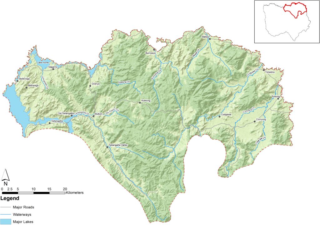
Introduction
An area of mountains, hills, valley floors and floodplains. It features high quality remnant vegetation, wilderness areas, beef and dairy production and tracts of softwood plantations.
Regional towns include Corryong and Tallangatta with other small towns, villages and localities across the landscape.
Many cultural heritage sites are maintained on public land and the area is of significance to the region’s Traditional Owners/First Nations Peoples.
The area has an ageing population, is experiencing population decline and has low economic diversity with a high dependence on agriculture.
In 2019-20 major bushfires severely impacted the landscape destroying or significantly damaging community and natural, built, and cultural assets.
What is important?
Important attributes
Important attributes of this landscape identified by those who live, work, visit or connect with this landscape include:
- A diverse, striking landscape valued by the community and remote from major cities
- Strong community cohesion, social connectedness and stewardship values
- High agricultural capability, fertile floodplains and healthy soils
- Recreational opportunities afforded by the Murray River, Lake Hume, parks, wilderness areas and reserves, historic sites. A hotspot for hunting and fishing
- Man from Snowy River Festival draws thousands of patrons each year to celebrate history and rural culture
- Healthy and clean waterways and high-quality remnant vegetation, many cultural heritage sites and storylines are maintained here.
Key features
| Theme | Key features |
| Land | Steep, rugged rocky ridges and broad, fertile plains and riparian corridors. Minor ranges extend across this landscape, including four places where elevation exceeds 1000m above sea level – Mount Lawson (1041 m), Pine Mountain (1062 m), Black Mountain (1219 m) and Mount Burrowa (1300 m). Burrowa – Pine Mountain National Park covers 18400 hectares and includes one of the biggest monoliths in the southern hemisphere. Livestock grazing is the predominant agricultural land use with some dairy farms within the area. Softwood plantations and native forests cover much of the mountainous landscapes. |
| Water | Upper reaches of the Murray River. Rivers drain into Lake Hume which is a major supplier to downstream users. Priority waterways include Koetong Creek, Cudgewa Creek, Corryong Creek, Burrowye Creek and Kane Creek. Lake Hume is listed as a nationally important wetland. With high rainfall the landscape is less dependent on irrigation for agriculture, with many farms having limited or no access to irrigation water. |
| Biodiversity | Valley Grass Forest (on fertile, gently undulating sites) and Grassy Dry Forest (more upslope, on somewhat drier sites of steeper gradient) are the most common vegetation communities, but have been largely cleared. Wilderness and significant forested parks including Burrowa-Pine Mountain National Park, Mitta Mitta Flora Reserve and Regional Park, Pheasant Creek Flora and Fauna Reserve, Mount Lawson State Park and Mount Granya State Park. Large old trees (sometimes single paddock trees) connect larger patches of remnant vegetation and serve as habitat for native species. Some important species and communities that are significant to this landscape include: Flora Green grevillea (Grevillea jephcottii) Summer leek-orchid (Prasophyllum uvidulum) Phantom wattle (Acacia phasmoides) Grey grass-tree (Xanthorrhoea glauca) Terrestrial Fauna Eastern wallaroo (Macropus robustus robustus) Greater glider (Petauroides volans) Powerful owl (Ninox strenua) Aquatic/riparian/wetland fauna Murray cod (Maccullochella peelii) Flat-headed galaxias (Galaxias rostratus) Trout cod (Maccullochella macquariensis) Great eastern egret (Ardea alba modesta) Booroolong frog (Litoria booroolongensis) Spotted tree frog (Litoria spenceri) Brown toadlet (Pseudophryne bibronii) Alpine spiny crayfish (Euastacus crassus) |
| Community/socio economic | Regional towns include Corryong and Tallangatta with other small towns, villages and localities across the landscape. These are more isolated from major cities than other landscapes within the region. Characterised by low density population, older residents, smaller households, mainly residential. Low economic diversity – high dependence on, and employment in agriculture. Forestry and tourism are also important elements of the local economy. Many cultural heritage sites are maintained on public land in the landscape. |
Condition
The following is a snapshot of condition for the Upper Murray Landscape.
| Theme | Condition |
|---|---|
| Land | Soil health issues include – soil structure decline and organic matter loss and acidic soils. 51% of land in the Upper Murray sub-catchment has a pH under 4.4 (extremely acid) and 22% of land had a pH between 4.4. and 4.9 (strongly acidic). The 2019-20 bushfires have significantly impacted soil health. Deer and blackberries impacting negatively on agricultural production and protected areas. |
| Water | Waterways and riparian vegetation in this landscape range from poor e.g. Tallangatta Creek to excellent in Koetong Creek. Most streams feeding into the Murray River have a fragmented, narrow band of streamside vegetation. Condition has declined in areas affected by 2019-20 bushfires. Rain after the 2019-20 fires washed large loads of ash, sediment, and debris into rivers and farm dams. Decomposing organic material reduced dissolved oxygen levels in a small number of waterways downstream of bushfires resulting in fish deaths. In-stream woody habitat is in excellent condition showing only minor variations from natural in some areas. Occurrence of blue-green algal blooms in Lake Hume has impacted on condition and water use. Drier conditions have led to decreased inflows into rivers. |
| Biodiversity | Relatively high-quality native vegetation providing corridors for native flora and fauna movement in some areas. Deer impacting negatively on biodiversity. The Burrowye Creek holds the first record of the booroolong frog in Victoria. The species has declined severely in numbers and distribution and is nationally endangered. Threats include habitat disturbance, the disease chytridiomycosis, and predation of tadpoles by introduced fish. The landscape is home to the green grevillea, a rare species also known as pine mountain grevillea. The species is endemic of Victoria and restricted to a small area of north east Victoria between Walwa and Corryong, centring on Burrowa-Pine Mountain National Park. The Greater glider (Petauroides volans subsp. volans) is threatened, with evidence of decline across its range in Victoria. The species is hollow-dependent, and loss of habitat is a significant threat to the species survival. Areas not been burnt by the 2019-20 fires are generally in moderate condition. Cleared areas typically have lower biodiversity condition. Significant repeat fire events and the 2019-20 bushfires have impacted on habitat and increased predation and exposure to pest plants and animals. |
| Community/Socio economic | Close community connections within individual valleys across the landscape. Many older residents, fewer young residents, small household size and relatively large percentage of population with lower incomes compared with other landscapes in the region that are closer to population centres. Majority are employed in agriculture and resources. Social connection is strong within the community however isolation and, poor digital connection pose issues for the community. Low multiculturalism and diversity. The communities are still recovering from the shock of the 2019-20 fires, as well as the impacts of COVID-19 lockdowns and social isolation. These acute shocks and other environmental issues such as feral deer, flooding and blackberries have galvanised already strongly connected communities in this landscape. |
What is changing?
The world and our region are changing rapidly and north east Victoria is more interconnected across multiple spatial scales than ever before. This section describes the major drivers of change identified by Traditional Owners/First Nations Peoples and the community during engagement for RCS renewal, and what this means for the Upper Murray landscape.
Drivers of change
| Driver of change | Leading to |
| Climate change and acute shocks and extreme events | Declining average rainfall and change in seasonal patterns. Increase in severity and frequency of extreme events will continue to impact water quality, biodiversity and communities. Decrease in resilience of natural resources and farm business in the area. In 2019-20 major bushfires impacted the landscape destroying or significantly damaging community and natural, built and cultural assets. It tested community resilience, created community fatigue and at the same time, strengthening community cohesion, self-organising and belonging. |
| Ageing population, isolation and population decline | Migration of people out of the area, especially young people. Decline in the number of farming families. Loss of knowledge of land management, stewardship and reduced capacity, particularly on private farming land. At same time opportunity for knowledgeable community champions to share knowledge and build capacity of next generation of land managers and farmers. Some concern over increased visitation and impacts on resources on recreational areas and public land. |
| Increasing invasive pest, plants/animals and pathogens | Increased occurrence and impacts of deer and wild dogs, especially after fire. Increased impacts on biodiversity including threatened flora and fauna. Increased impacts on farm businesses e.g. stock loss from wild dogs. Self-organised community-driven initiatives to control invasive pest plants and animals. Pest plants and animals are a drawcard for engaging land managers on NRM and stewardship. Chytrid fungus is threatening frog survival.[45] |
| Changes in governance | Strengthening of empowerment and self-determination of Traditional Owners/First Nations Peoples, increased interest in learning about Traditional Owners/First Nations Peoples history and culture and integration of cultural objectives and methods into NRM. Bushfire Recovery Victoria establishing Community Recovery Committees across the landscape. Potential increases in public access to Crown land water frontages with grazing licences. New environmental laws from 1 July 2021 give the EPA more powers to prevent risks to environment and public health and require dairy farms to manage effluent. Policy to end native timber harvesting by 2030, that poses risk of job losses in north east Victoria. Multiagency framework for emergency management is complicating community perception of how extreme weather events are managed. Community perception that there are fewer resources to manage public land and fewer staff to enforce some legislative changes such as access to crown frontages. Some confusion on different agencies’ roles, responsibilities and how they work together. |
| Increased reliance on technical innovation | New rapidly advancing technology reliant on internet and mobile coverage which can be limiting in parts of this landscape. Concern over access to information and awareness of emerging best practice. Increasing isolation of communities. Migration of young people out of the area, due to technological disconnection. |
Outcomes and priority directions
Key outcomes and priority directions for the RCS have been developed, drawing on information and discussions with people who live, work, visit and connect with north east Victoria.
Outcomes and their associated priority directions, that are important to the Upper Murray from the regional themes of biodiversity, water, land and community include:
Biodiversity
- By 2040, an increase in the extent (ha) and connectivity of native vegetation across north east Victoria.
- By 2040, an increase in the area of natural environments protected and remnant vegetation enhanced.
- By 2040, improved trajectories for priority native icon, threatened and culturally significant species and ecological communities’ (priority species and communities).
- By 2040, an increase in understanding and focus on supporting resilient biodiversity in a changing climate.
Land
- By 2040, land management practices are culturally appropriate reflecting Traditional Owner/First Nation aspirations.
- By 2040 community resilience and land management practices are continually adapting to accommodate challenges of climate change and extreme events.
Community
- By 2040, an increase in the number and diversity of individuals and organisations supporting Landcare and community NRM groups in north east Victoria.
- By 2040, an increase in participation by visitors and absentee landholders caring for, and stewarding the natural environment across north east Victoria.
- By 2040, an increase in diversity of investment in NRM in north east Victoria.
- By 2040, Traditional Owners/First Nations Peoples knowledge and practice is healing, adapted to a contemporary context and applied to both heal and care for Country.
Water
- By 2040, waterways are healthy and well managed thereby protecting waterway-dependent iconic, culturally important and threatened (priority species) species.
- By 2040, there is improved protection of water quality and waterway/wetland/floodplain system values during and following extreme events.