Vision
Healthy river systems and connected native vegetation thriving alongside productive agriculture and recreation
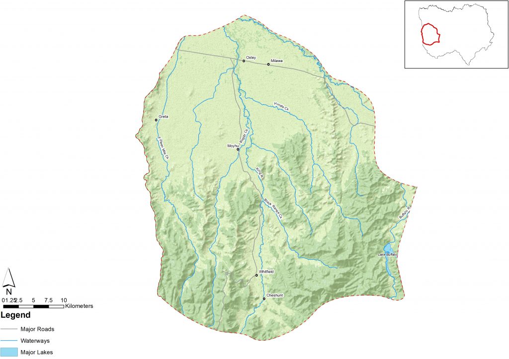
Introduction
This area is similar to the Central Mountain Valley, with a combination of both mountain landscapes – usually public land – and cleared valley floors, used mainly for agriculture.
Agriculture in the fertile valleys is mainly dairy viticulture, along with grazing and mixed farming on the plains closer to Wangaratta. Softwood plantations also occur within this landscape.
Regional towns include Whitfield and Oxley with several other small towns, villages and localities scattered across the area.
Recreational hunting is common in this area due to increasing deer numbers.
This landscape is significant to several Traditional Owners/First Nations Peoples. The confluence of the Ovens and King is on the boundary of two Registered Aboriginal Parties and there is anecdotal evidence that Black Dog Creek was an important trading route.
What is important?
Important attributes
Important attributes of this landscape identified by those who live, work, visit or connect with this landscape include:
- Physical evidence of Traditional Owners/First Nations Peoples cultural values within the system along the waterways in the form of scar trees and scattered artefacts
- Agriculture trends indicate an increase in intensive small-scale horticulture, gourmet produce and agri-tourism
- The King Valley is known for a variety of Mediterranean grapes including prosecco and other high-quality viticulture. Food and wine festivals draw thousands of visitors to the valley each year
- Dairy is also a dominant agricultural industry
- The picturesque nature of the Valley supports recreation industries such as trout fishing, four-wheel driving, rafting, deer stalking and bushwalking
- Volunteer groups and engaged communities that demonstrate social leadership and capacity to be self-sustainable.
Key features
| Theme | Key features |
|---|---|
| Land | A unique landscape valued for aesthetics. Sheep and cattle grazing, horticulture, dairy, viticulture, and rural residential properties are the major land uses. Hardwood and softwood forest production is also a major land use in the southern part of the area. Remnants of riverine grassy woodlands and floodplain riparian woodlands exist within a highly fragmented landscape. The steeper sides of the valleys remain in native eucalypt forests in the upper reaches of the King River and open out into fertile river flats between 20 km and 42 km wide north of Moyhu. |
| Water | Priority waterways include King River, Stony Creek, Station Creek, Hurdle Creek, Boggy Creek, Black Range Creek, Fifteen Mile Creek and Factory Creek. King River is characterised by a high energy, fast moving system with a cobble-based riverbed upstream with small rapids, this changes into a coarse-grained riverbed downstream. Wetlands are mostly deep freshwater marshes or freshwater meadows. Lake Buffalo is located on the Buffalo River, 24 km south of Myrtleford. It is at the foot of the western slope of Mount Buffalo National Park and has a capacity of 23,340 ML. Groundwater is found approximately five metres below the surface and mostly evident in the lower landscapes of the King Valley.[68] |
| Biodiversity | Good numbers of two-spined blackfish, river blackfish and Murray cod as well as southern pygmy perch between Moyhu and Edi. The endangered growling grass frog has been found in the mid-reaches upstream of Cheshunt. Species of egrets, shovelers, bitterns, geese and tree-creepers, kingfishers, herons and sea-eagles are present, lower down in the system. Plains Grassy Woodlands and large older trees (sometimes single paddock trees) within the system are noteworthy, as they play an important habitat role in the system. Habitat restoration has resulted in sightings of Critically endangered Regent Honeyeater (Anthochaera phrygia) in this landscape. River red gum woodland, and associated larger patches of aquatic vegetation, provide a significant regional wildlife corridor – a conduit for migrating forest woodland birds e.g. robins, whistlers, warblers and flycatchers moving between the foothill forests and the woodlands of the plains. Some important species and communities that are significant to this landscape include: Flora River red gum woodlands Concave pomaderris (Pomaderris subplicata) Terrestrial fauna Superb parrot (Polytelis swainsonii) Long-nosed bandicoot (Perameles nasuta) Aquatic/riparian/wetland fauna Two-spined blackfish (Gadopsis bispinosus) River blackfish (Gadopsis marmoratus) Murray cod (Maccullochella peelii) Trout cod (Maccullochella macquariensis) Southern pygmy-perch (Nannoperca australis) Growling grass frog (Litoria raniformis) Platypus (Ornithorhynchus anatinus) Wetland birds |
| Community/Socio Economic | Towns with greatest population include Cheshunt, Whitfield, Edi, Moyhu, Oxley and Milawa. The confluence of the Ovens and King is on the boundary of two Registered Aboriginal Parties and there is anecdotal evidence that Black Dog Creek was an important trading route. Towns such as Milawa and Oxley are close enough to Wangaratta to function as dormitory suburbs. Rural population is more highly educated than similar landscapes in the region. Proximity to the cities of Wangaratta and Benalla means these areas are far less isolated.[69] Community involvement in the system is strong, with many active community groups engaged in supporting waterway management. |
Condition
The following is a snapshot of condition for the Foothills – mid Ovens and King Landscape.
subdivison of town land is losing some and also illegal removal and loss through solar farm development
| Theme | Condition |
|---|---|
| Land | The loss of paddock trees in the wider landscape is leading to habitat fragmentation due to various developments such as residential and solar farms. Frequency of bushfires and repercussions of smoke damage has affected the local viticulture industry. High risk of soil acidification in the lower reaches of the King Valley. Soil carbon stocks are generally steady with potential for increases under current or altered land management. |
| Water | In-stream woody habitat is severely depleted in Factory Creek and moderately to highly depleted in the mid Ovens and King rivers.[70] The foothills landscape waterways are generally in moderate environmental condition. The upper King River and Buffalo River West Branch were in excellent condition but were impacted by the 2019-20 bushfires. Significant past investment in willow management and re-vegetation has led to improved riparian health. Waterway avulsions occur in Lower King River into Croppers Creek, Centre Stream and an active breakout into Meadow Creek, creating a tension between agricultural land use and natural river movement. Fifteen Mile Creek has shown elevated levels of phosphorus and turbidity, which may be attributed to run-off from the surrounding cleared sloping river valleys.[71] Low salinity in groundwater and surface water resources.[72] Goulburn-Murray Water forecasts a reduction in water reliability for the King River caused by changes in inflows under new climate change conditions.[73] |
| Biodiversity | The macroinvertebrate community in the King River varies from excellent to very poor.[74] The native fish community of the system is in moderate condition due to multiple threats such as in-stream habitat quality. King River in-stream habitat has been improved in recent years.[75] Concave pomaderris (Pomaderris subplicata) is endemic to north east Victoria, and the only remaining populations are found in the Carboor area. Revegetation programs have enhanced the wild population across crown land, roadsides and private land – which now has approximately 600 plants. Plains Grassy Woodlands are endangered in this landscape. |
| Community/socio-economic[76] | Small household sizes accommodating older residents in the upper reaches of this landscape. Household size gradually increases and median age is lower closer to Wangaratta. Lower rates of tertiary education and significant employment in industries such as agriculture, fisheries and forestry. In the upper reaches of the landscape multiculturalism and diversity is high. There is less multiculturalism in the lower reaches towards Wangaratta. Owner-operator farms are declining, residential housing development is increasing and larger parcels of land are being sub divided for lifestyle properties. |
What is changing?
Our region is changing rapidly and north east Victoria is more interconnected across multiple spatial scales than ever before. The table below describes the major drivers of change identified by Traditional Owners/First Nations Peoples and the community during engagement for RCS renewal and what this means for the Foothills – mid Ovens & King landscape.
Drivers of change
| Driver of change | Leading to |
| Climate change and acute shocks and extreme events | Extreme weather events such as increased fire and storm frequency and intensity. Bushfire smoke impacting negatively on vineyard harvest. Fire impacts causing excessive runoff after heavy rains which can exacerbate flooding and carry high loads of sediments and nutrients into waterways. Vulnerability of valley communities to fire and flood due to proximity to forested public land and waterways. Periods of drought and water scarcity will challenge agricultural, environmental and community resilience. |
| Land use change | Increase in demand for land for urban, rural residential and lifestyle uses. Expansion of urban boundaries around Wangaratta encroaching into King Valley. Fragmentation of riparian vegetation corridors, habitats and linkages between blocks of remnant vegetation. Change in land use as solar farms are developed. Loss of paddock trees. Change in community expectations and attitudes toward level of services with increasing rural residential and tourism. |
| Increasing invasive pest plants and animals | Pest plant and animal control is a first step to engaging land managers on NRM and stewardship. Increased occurrence and impacts of deer, wild dogs, rabbits, feral cats, feral pigs. Increasing re-infestation of willow species through waterways that were previously managed due to lack of maintenance. Changing distributions of native bird species, especially budgies and crimson chats. Blackberries blocking access to waterways for recreational use. |
| Ageing population and young people moving out of the area | Disconnectedness with community. Losing ability to pass down knowledge of sustainable land management and uniquely important landscape information. High cost of land means there are significant barriers to entry for younger generations wishing to start agricultural businesses. |
| Change in governance | Empowerment and self-determination of Traditional Owners/First Nations Peoples is being integrated into planning and community decision making. Taungurung Recognition Settlement Agreement redefining NRM and relationships. Recognition of Traditional Owners as RAPs is often contested between multiple Traditional Owners/First Nations groups. Potential increases in public access to Crown land water frontages with grazing licences. Short-term funding inadequate to achieve outcomes in the long-term. |
| Shifting waterway regimes | Increased rates of bed instability. Barriers in waterways reducing habitat connectivity and fish passage. Waterway avulsions that threaten agricultural enterprises, infrastructure and property. Seasonal demands for agricultural and urban water supply affects flow regimes downstream of Lake William Hovell. |
Outcomes and priority directions
Key outcomes and priority directions for the RCS have been developed drawing on information and discussions with people who live, work, visit and connect with north east Victoria at a regional and local scale.
Outcomes and their associated priority directions, that are important to the Foothills – mid Ovens and King from the regional themes of biodiversity, water, land and community include:
Biodiversity
- By 2040, an increase in the extent (ha) and connectivity of native vegetation across north east Victoria.
- By 2040, an increase in the area of protected natural environments and enhanced remnant vegetation.
- By 2040, improved trajectories for priority native icon, threatened and culturally significant species and ecological communities (priority species and communities).
- By 2040, an increase in the understanding and focus on supporting resilient biodiversity in a changing climate.
Land
- By 2040, land management practices are culturally appropriate reflecting Traditional Owner/First Nations Peoples aspirations.
- By 2040, community resilience and land management practices are continually adapting to accommodate challenges of climate change and extreme events.
Community
- By 2040, an increase in the number and diversity of individuals and organisations supporting Landcare and Community NRM groups in north east Victoria.
- By 2040, an increase in the participation by visitors and absentee landholders caring for, and stewarding the natural environment across the north east.
- By 2040, an increase in diversity of investment in NRM in north east Victoria.
- By 2040, Traditional Owners/First Nations Peoples’ knowledge and practice is healing, adapted to a contemporary context and applied to both heal and care for Country.
Water
- By 2040, waterways are healthy and well managed thereby protecting waterway dependent iconic, culturally important and threatened (priority species) species.
- By 2040, there is improved protection of water quality and waterway/wetland/floodplain system values during and following extreme events.